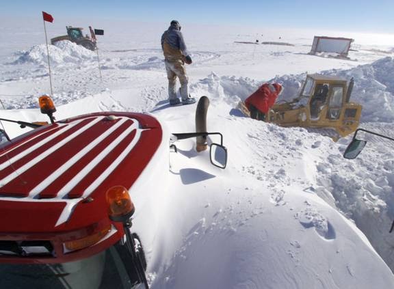
Mt. Erebus Lets Off a Little Steam

Thursday, December 16, 2010

All Points North

On December 14, 1911, Roald Amundsen was the first explorer to stand at the South Pole and have his picture taken.  On December 14, 2010 (exactly 99 years later), I did the same.  My trip was considerably easier than his, and scarcely what I could call a hardship.  My trip was immensely more comfortable than that of the Robert Falcon Scott expedition that arrived a month later than Amundsen, only to find a Norwegian Flag planted where they had hoped to be the first to set foot.  Tragically, the entire Scott Expedition Polar Party perished on the return trip.  I would stay at the comfortable Amundsen Scott South Pole Station.


My trip started when I boarded an LC-130 “Ski Bird,” and heard eleven of my favorite words, “Chaplain, would you like to ride up on the flight deck.”

"OK, Guys, let's take a heading south."

 From the flight deck, some cloud cover obscured a good part of the route that the Scott party took 99 years ago.  I did get some pictures of the Trans-Antarctic Mountain Range, and the Beardmore Glacier that they used to climb up to the great expanse of accumulated ice and snow that is called the Polar Plateau. 

The Trans-Antarctic Mountain Range

The Beardmore Glacier winds its way down from the Polar Plateau
When you say, “South Pole,” you may be thinking of one of three different places: If you followed your compass, you would find the Magnetic South Pole, which is somewhere out in the ocean off of French Adelie Land, outside the Antarctic Circle.  Another South Pole is the “Ceremonial South Pole,” which stays in the same place relative to the surface of the roughly 9,000 feet of ice that rides over the pole.  What most would say is the “real South Pole,” is the geographic South Pole that is the actual point of the earth’s rotation, projected to the surface and marked by a special marker designed by a different artist each year. 

I noticed, as we flew, that the pilot’s magnetic direction indicator pointed to about 340 degrees—give or take a few.  When you remember that a compass only has 360 degrees, one would guess, based on that instrument, that we were flying almost due North.  That says something about the difficulty of navigating down here, especially when there is limited visibility.  Even following a normal chart (or map, as we would say) is complicated by the fact that the longitudinal lines get closer and closer together until they merge at the pole.  There’s not much space between those lines to put anything to navigate by.  To solve that, an entirely different set of grid lines is used on these charts.  Well, thank goodness for GPS; though there are not as many Global Positioning Satellites this far south as there are in other more traveled regions.  For good measure, unlike most modern air ships, we carry a navigator.
So, This is the bottom of the world!
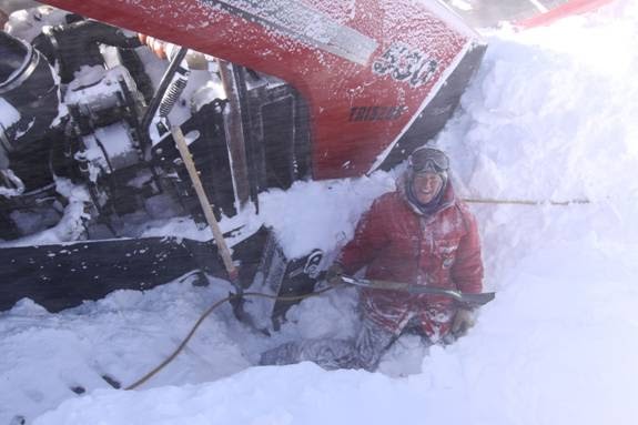
What should we expect when we land?  Well, for one thing, we would expect it to be cold.  Even in mid-summer, as it will be next week, temperatures usually stay between minus 10 and minus 20 degrees Fahrenheit--cold, but not intolerable for a Montanan. 

Secondly, remember all of that snow packed ice?  It doesn’t snow much here, but since it seldom, if ever gets above freezing, most of that snow doesn’t go very far.  What doesn’t get packed into ice just blows around the continent and makes a nuisance for those few hardy souls who try to make a living here.  Anyway, it has been collecting for so long that it is nearly 2 miles deep. (Remember that Denver is a mere 1 mile high.) All of that snow is so heavy that it actually squashes the earth at the bottom, so that the earth is more pear-shaped than round.

What I’m getting around to is the potential for altitude sickness.  Though the ground beneath us is actually near sea level, the official altitude at the Pole is 9,186 ft.  Add to that, the low barometric pressure which fluctuates from day to day, and the effective altitude (pilots need to know this) is usually over 10,000 ft.  For those of you from Montana, it’s like living at the top of Bear Tooth Pass.  Living here takes some getting used to.  Flying from sea level and landing at this altitude is a shock to the system.  By the time I carried my bag up one flight of stairs, I was feeling like I’d been on the tread mill for half an hour.

In the third place, this is the driest part of the driest continent on earth.  It seems nearly impossible to put down enough fluids to keep from getting completely dehydrated.  The Diamox pills I was taking to help fight altitude sickness have a diuretic effect.  To put it politely, it elevates the rate of urination.  It can also make a person rather sleepy.  Put together massive fluid intake with accelerated output, and you get a sense of what the first night’s sleep was like. 

Whoever had last slept in the berth that I was assigned, wanted more floor space, and elevated the bed nearly to the ceiling.  Even as a tall man, I had to climb up the end of the bed to get in and climb back down to get out.  Having had very long day, I fell peacefully asleep. When the urge would strike, I would climb down and go to the rest room down the hall.  Then I would climb back up, settle back in, and fall asleep until the next urge.  Did I mention that this is at 10,000 ft.?  Did I mention that I was out of breath climbing one flight of stairs. Sheesh!
The bed in my berth was lofted almost to the ceiling

The “Polies” (as they call themselves) were very friendly, and the food was good.  I offered two worship services, one at and another at , so as to catch people somewhere during the 3 work shifts that go on around the clock for the 250 people on station.  (Since the sun never sets in the summer, it makes very little difference which shift you work.)  The services were lightly attended, but very rewarding for me.  In between, I did the tourist thing; got my picture taken by two of the poles and took a walk around the “summer camp,” where many of the summer workers live.  I mailed some post cards, and (of course) bought the T-shirt.
The Geographic Pole
Note the date stamp on the picture is the same date as on the sign
Behind me is the Amundsen Scott South Pole Station
The tower on the left is called "The Beer Can," can you guess why?
 
The Ceremonial Pole
I had good food and conversation in the Galley

The "Summer Camp"

"Jamesways" for living quarters at "Summer Camp"

Snow continually threatens to bury the Station
This is the view looking North...from any direction...for hundreds of miles.

I had originally planned to spend another night at the Pole and catch the first flight to McMurdo in the morning.  But hearing that the only flight that day wasn’t going to arrive until 10:10 PM, (about the same as the one I came in on) and knowing that flights in and out of here are very unpredictable—and, perhaps, remembering the exercise I had, climbing in and out of bed the night before, I elected to take the 10:30 flight out.  That would get me to the Pegasus Ice Runway at about .  The trip across the Sound to McMurdo station ended up taking an hour and a half, so I would get home at .  At least I would be home before dark.

As I boarded the plane, I heard eleven of my favorite words again, “Chaplain, would you like to ride up on the flight deck?”  Yes!


Sunday, December 12, 2010

Chapel Time

Chapel at McMurdo is an interesting mix of civilian and military aviators, scientists and students, trade workers, suppervisors and hired hands.  As Christmas approaches the chapel gets a little busier, as you might expect.  Besides the weekly Bible study, and weekly theological discussion group, there is now a caroling choir.  Peer counselors are trained by the chaplains and advised by medical professionals.  An assortment of groups use the chapel, from Yoga classes, to Alcoholics Anonymous.  Soon there will be a decorating team to "deck the halls."  It's slowly starting to look like Christmas at McMurdo, but not nearly as early as it does back home.  Christmas will bring mixed feelings for us, as we enjoy the warmth and closeness of our community here, and miss our loved ones eight thousand, or so, miles away.

Father Kevin Leads Mass at 9:45

11:00 O'Clock is for the Protestants


Saturday, December 11, 2010

A Little Trouble

This year's traverse to the South Pole had a little trouble along the way.  Here are some pictures they sent.  I don't know the whole story, but I heard they got into a storm as they got close to the Pole this week.  Looks like they have a little digging out yet to do.

December 8, 2010

December 8, 2010

December 9, 2010

December 9, 2010

December 9, 2010

December 9, 2010

December 10, 2010

December 10, 2010

December 10, 2010

December 10, 2010

Tuesday, December 7, 2010

An Incredible Journey

I know I sometimes go for several days without posting.  The reason is that I have lots of work to do here and not every day is new and exciting.  Also, I need some time to sort out what is worth telling and how to tell it.  I've tried to stick almost entirely to experiences that I have had personally, and not share second hand stuff that someone else could tell better.  If I'm looking it up on the internet in order to share it with you, I might as well send you to the source.   So while I'm working on my next post, I want to share another blog with you that I think is facinating.

I asked someone several days ago about a traverse to the South Pole that I had heard about.  She said, "Oh, they left a few weeks ago."  I wanted to know more, so I went googling.  Here's basically what I'm talking about:

Since there is no way to bring a seagoing ship to the South Pole like we do at McMurdo, all of the supplies for South Pole Station are brought in by aircraft, including a massive amount of fuel.  There has been one exception in recent years though.  Every summer there is a small caravan of brave souls that drive the thousand miles between McMurdo Station and Amundsen Scott South Pole Station, basically making their own road as they go.  They follow, essentially the same route as the original Scott expedition, accross the Ross Ice Shelf, up the Beardmore Glacier and across the long-flat expanse of the Polar Plateau.  Their mission is to drag huge bladders of fuel to the Pole and return the same way they came.  You can imagine that it takes some pretty exotic vehicles to make that crossing; and that they have some great stories to tell when they come back. While I'm somewhat jealous, I'm not sure I would volunteer for that two month journey, when I can go--as I expect to next week--by way of a five hour (each way) plane trip.  I'll tell you about that when it happens, but in the mean time, enjoy this blog that was posted about last year's traverse to the South Pole.  I think you'll be amazed.
Click on the link below--and remember that it's a blog, so you read from back to front.  Or, if you're in a hurry, go straight to the pictures on the right and click on "Traverse History," and "Traverse Photography."

SouthPoleTraverse.html

Saturday, December 4, 2010

Wow! Freshies!

I saw a longer than usual line at one of the serving centers this noon in the galley.  Why such a line?  Then I realized it was a salad bar!  There were lots of greens (with a little lettuce mixed in), and there were cherry tomatos (a rather pale orange, but tomatos none-the-less).  Sliced cucumbers, and all sorts of toppings.  There was a minor feeding frenzy. Plates were heaped high. We take seriously the words of Jesus, "Don't worry about tomorrow, when there are 'freshies' today" (loose translation). Oh, the simple joys of life!

Friday, December 3, 2010

Long Duration Balloons

Today I was invited to visit the Long Duration Balloon (LDB) project.  This is actually four projects, funded by grants from NASA.  University programs can apply for grant money for projects the will provide data that will complement NASA’s own research. Something in the realm of 1 in 50 applicants will actually win these grants.
Large unmanned helium balloons are an inexpensive way to bring diagnostic equipment to the edge of space.  Long Duration flights can be made in Antarctica, because a persistent large low pressure vortex forms over the South Pole about this time every year.  When the ideal conditions develop, the upper level winds will circle the Antarctic Continent, allowing the balloon payloads to be carried for days or weeks and still be recovered once they land on the continent.  Once the best possible location is determined, the balloon can be deflated and a parachute brings the cargo to the ground, hopefully in a area where it can be safely recovered. 


An ideal scenario would be that the balloon circles the continent two or three times and is dropped within visual range of the launch pad.  The worst case is that it gets carried out to sea and becomes unrecoverable, or lands in a crevasse or other bad spot.  Some smaller payloads can download all of their data from the sky and are relatively expendable.  To lose some of the larger payloads would be very expensive in loss of equipment and data.
 The LBD launching pad is constructed on the permanent ice of the Ross Ice Shelf.  To get there, I climb on board “Ivan, the Terra Bus" (all of the vehicles seem to have names here).  Ivan lumbers over the hill to Scott Base and then on to the ice shelf to the launch facility in the middle of the ice shelf and about 15 miles from McMurdo Station. 
Ivan Awaits

 Scientist and others working on the project live at McMurdo and commute to the site daily.  The camp has most of the comforts, including a dining hut that serves remarkably good food, and a number of other large buildings that are towed down from their winter storage place.  The launch pad is made by working the snow and ice into a firm and level platform about the size of several football fields.  In the event of bad weather (which could be in the works for this weekend) workers can stay at the camp for days and even weeks if necessary.  In fact I was reminded by project leaders that the last chaplain that visited here stayed for three days before the weather cleared.  For larger balloons and payloads, a specially designed crane holds the payload while the balloon is launched to keep it from being dragged across the ice by the rising balloon.

Note the buildings are all on sleds

A great lunch is served here

This crane is built to hold a large payload while the balloon assends, not allowing the balloon the drag the payload across the ice.

The four projects I was shown today (in my own limited recall and understanding) are these: 
One of the larger payloads to be launched will be BLAST (Balloon Born Large Aperture Sub-Millimeter Telescope).  This telescope looks at the dust clouds in our own galaxy and studies them to learn more about the formation and evolution of stars being formed in them.

BLAST

Tracking Data
CREAM (Cosmic Ray Energetics and Mass) studies the origins of cosmic rays, detecting and analyzing cosmic rays emitted from exploding super novas.

CREAM
These scientists come from South Korea, by way of the University of Maryland.
They are regular attenders of chapel.
We are making fun of--what else?--my hight.


This payload is designed to monitor and test NASA’s Super Pressure Balloon (SPB).  The SPB is designed to expand and contract with changing temperatures, without releasing either gas or ballast in order to maintain a constant altitude.  The balloon will be monitored by cameras and other instruments as it follows wind currents around the Antarctic Continent.
File picture of SPB through a telescope
I, for some reason, didn’t take pictures of  BARREL (Balloon Array for RBSP Relativistic Electron Losses). An array of balloons will be launched to study electrons that escape the radiation belt above the earth as they Earth's atmosphere.  Complimentary NASA satellites will monitor the electrons within the radiation belt itself.  This is the smallest of the payloads I saw.  Essentially it is a Styrofoam box encasing the electron detecting instrument and some communication equipment to relay data to the ground.  Attempts will be made to recover all of these payloads, but there will be no major expensed or lost data if they are not.

Keeping a close eye on the weather in hopes of launching within two or three weeks.


Thursday, December 2, 2010

Ice Roads and Strange Looking Trucks

I thought I'd share some pictures of the trip to Cape Evans a couple of weeks ago.  We traveled about 15 miles around Ross Island by way of an ice road, which takes about an hour each way.  Speeds are slow.  Even though the ice is still fairly thick, it can be damaged by high speed traffic.

"You guys get into one of the Deltas"

We'll drag the road with the Challenger"

"Here they come"  "They look like something out of Star Wars"


On-coming traffic

"He'll pass on the side"

"There he goes.  The drag is working nicely"

"Stop ahead...Looks like there's something to see"

Mt Erebus is an active volcano


"Hey, check out the ice cave underneath the Erebus glacier!"
 
"You want me to crawl into what?"
 (It was cool,  but I didn't get any good pictures.)  Let's continue.


"We have to go to the right of that island"
This ice berg didn't quite get away before the winter freeze

"There they are"

It only took us an hour to drive 15 miles to Cape Evans
"It's getting close to 10:00 PM, we'd better start heading home."

"The Challenger's too slow and bumpy.  I'm riding home in one of the Deltas"